Osborne JV
The Osborne JV project is currently being advanced under an unincorporated joint venture between GreenTech Metals (51%) and Artemis Resources (ASX:ARV; 49%) (Osborne JV). The Osborne JV project area is highly prospective for lithium and nickel. High grade lithium pegmatites have been discovered with assays returning up to 3.6% Li2O (mineralisation confirmed as spodumene) over a combined 5km strike length at the Southern Trend with widths of up to 40m.
Location and Tenure
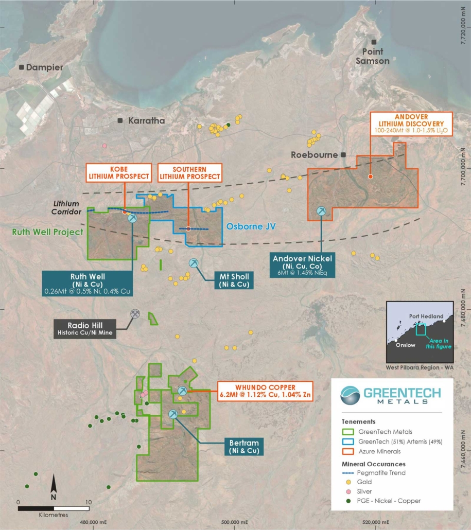
The Osborne JV project area consists of one exploration license (E47/3719) located approximately 15km southeast of Karratha in the West Pilbara region of Western Australia, covering an area of approximately 45km2 within the West Pilbara Mineral Field. Access to the Osborne JV project area is via a well maintained road heading southeast from the Karratha Industrial Estate, cutting through the eastern side of the project area then onto exploration tracks.
Prospectivity and Forward Exploration Program
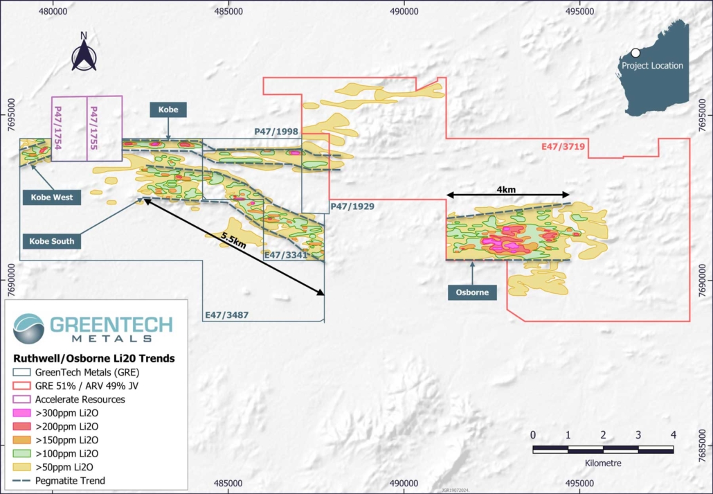
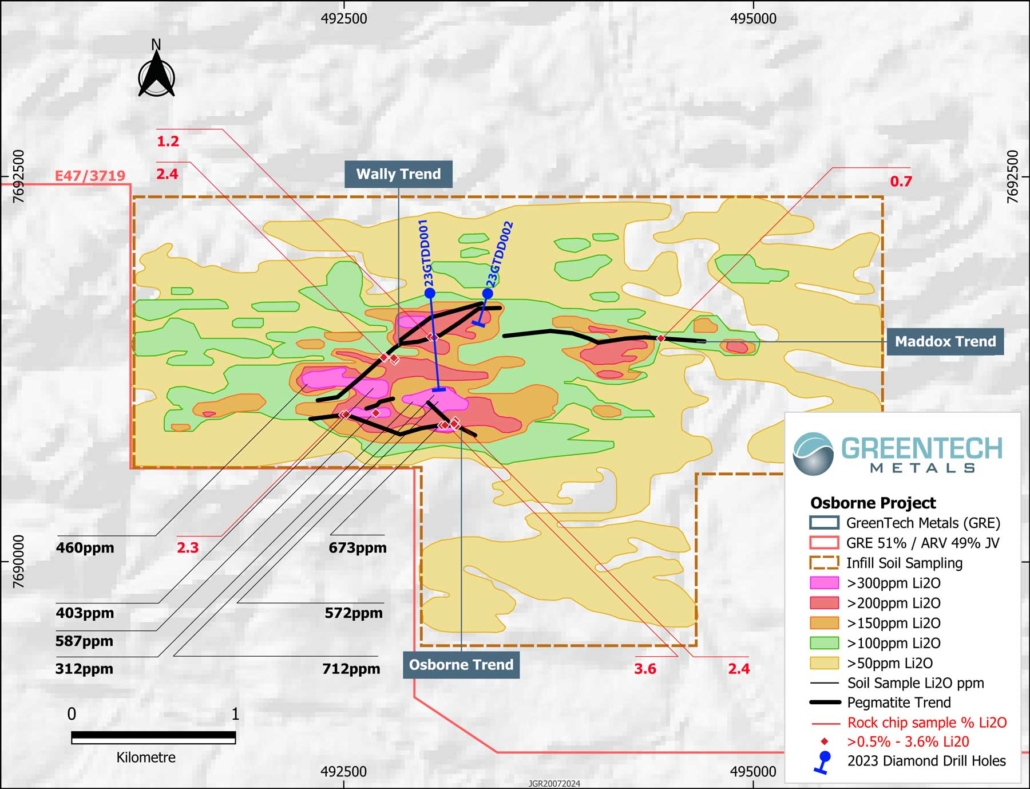
The Osborne cluster of pegmatites comprises the Wally, Maddox and Osborne trends and is defined by a large associated anomalous lithium soil footprint which has a strike of ~4km and a width of up to 1.3km. Reconnaissance rock chip sampling has confirmed the prospectivity of this pegmatite cluster with assays returning up to 3.6% Li2O. The anomalous soil footprint eclipses the size of the observed pegmatite outcrop and indicates there is potentially more to be discovered at Osborne. Mineralisation has been confirmed as spodumene.
The surface sampling indicates that the Osborne pegmatite trend is the most prospective pegmatite within the cluster so initial future work will aim to identify the full extent of this mineralised pegmatite trend and the consistency of the lithium minerology and grade. Preparations have commenced to enable a maiden RC drilling programme to be undertaken.
Geology
The Osborne JV project area contains three major geological units: the Roebourne and Whundo Groups, which are separated by the regionally significant E-W trending Sholl Shear Zone, and the overlying Cleaverville Formation.
Previous Exploration
The first reported regional exploration which covered the project tenement was undertaken by Westfield Minerals NL and Whim Creek Consolidated NL (Whim Creek), who were actively exploring from 1964 to the late 1970s. Several nickel-copper and base metal deposits and prospects were found but apart from some limited copper oxide open pit mining at Whundo in 1976, none of their prospects was developed into a mining operation.
From the early 1980s to 1992, Agip Australia Pty Ltd (Agip) took over from Whim Creek as the principal regional explorer. Their field activities included detailed mapping; soil geochemistry; aerial, ground and down hole geophysical surveys; and follow-up drilling. In 1988, an extensive aerial magnetic survey was flown at a line spacing of 100 metres which covered the project tenement. This contributed to the discovery of the Radio Hill nickel-copper deposit in 1984 and high grade silver deposit at Elizabeth Hill in 1987.
In 1993, Dragon Resources Ltd (Dragon) acquired some of Agip’s old ground, which included the area of the current project tenement. Dragon completed programs which included an airborne magnetic survey at 200 metres line spacing flown in 1994. Numerous targets were outlined for gold, nickel-copper, PGE and VMS mineralisation. Despite this, little detailed follow-up work was undertaken.
Dragon eased back on its West Pilbara exploration exposure in early 1998 with most of their relinquished ground subsequently picked up by Legend Mining Limited (Legend) in the early to mid-nineties. After 2005, Legend undertook a desktop aeromagnetic modelling study over the Cleaverville Formation BIF aimed at evaluating the magnetite potential of its entire Pilbara Project. The study was focussed on a 20 kilometre strike length of BIF within the Cleaverville Formation where 11 kilometres of which lies within the Osborne JV project area.
Further regional work by Legend was limited to carrying out several airborne VTEM surveys followed up by 12 ground EM surveys and some limited geochemical sampling. This work generated 10 priority targets requiring drill testing. Three targets, Paton, Hickmott and Osborne, lie within the Osborne JV project area.
Figure 1: Osborne JV project location
Figure 2: Lithium soil trends at Kobe and Osborne
Figure 3: Soil sampling anomalies and outcrop mapping to date in the Osborne JV project area
Figure 4: Pegmatite outcrop at the Southern Trend within the Osborne JV project area


