Ruth Well
Recent reconnaissance rock chip sampling at the 100% owned Ruth Well project area has confirmed multiple high-grade lithium bearing pegmatites. Assays have reported up to 2.3% Li2O with the mineralisation confirmed as spodumene. The pegmatite bearing zone extends for 7.5km of strike with individual pegmatite outcrop widths varying up to 6m at surface. The Ruth Well project area contains a historic nickel deposit.
Location and Tenure
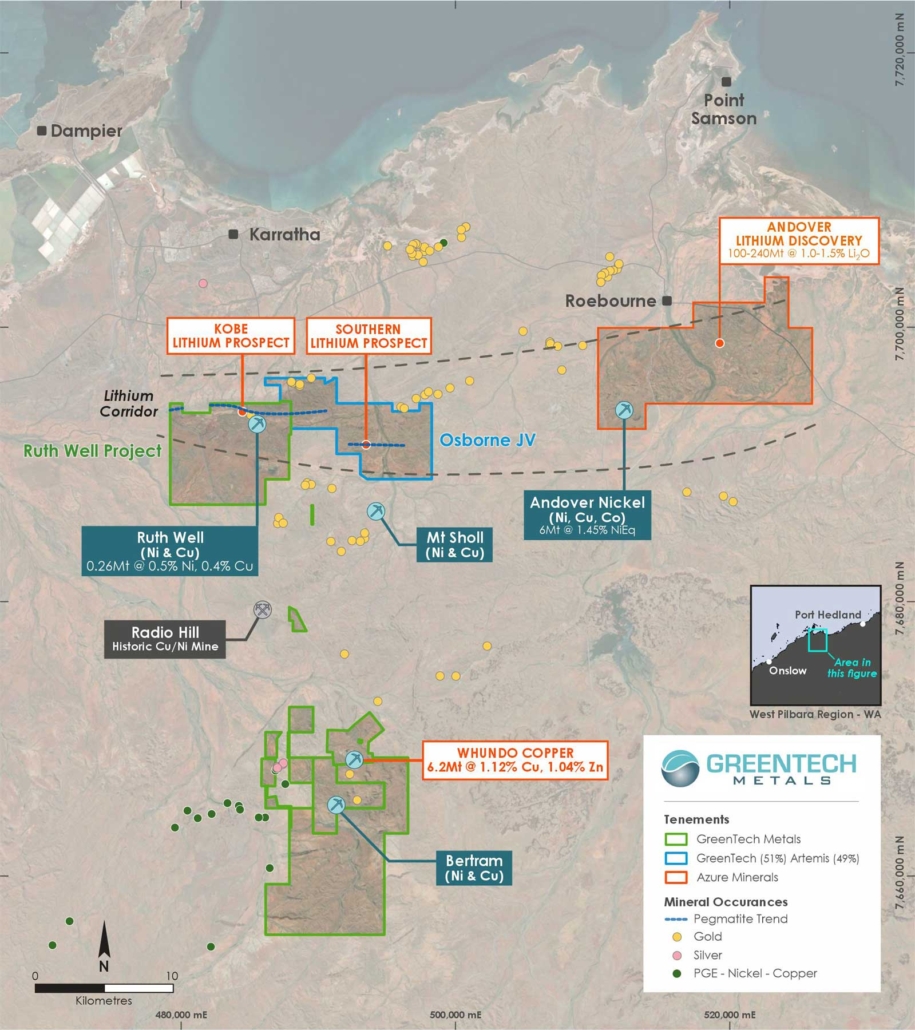
The Ruth Well project area comprises four exploration licences (E47/3340, E47/3341, E47/3390 and E47/3487) and two prospecting licenses (P47/1929 and P47/1998) located approximately 15km south of Karratha in the West Pilbara region of Western Australia, covering an area of approximately 58km2 within the West Pilbara lithium corridor. Access to the Ruth Well project area is via the sealed road to Tom Price heading south from Karratha then eastward on exploration tracks.
Prospectivity and Forward Exploration Program
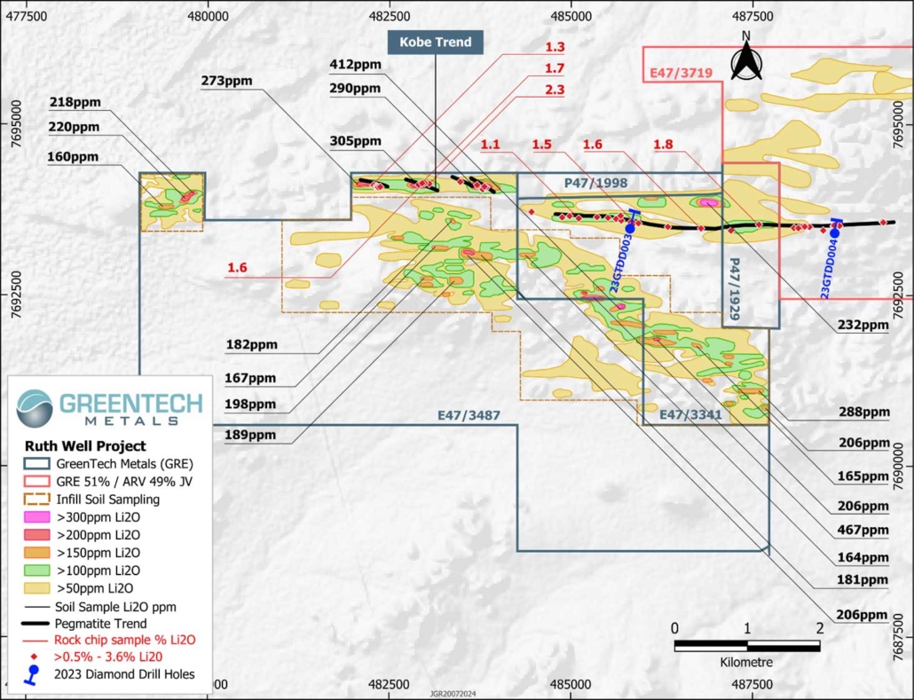
Reconnaissance rock chip sampling conducted in 2023 confirmed the presence of a high-grade lithium pegmatite trend (Kobe Trend) with assays returning up to 1.8% Li2O and with mineralisation confirmed as spodumene. The pegmatite bearing zone is up to 200m wide and with individual pegmatites up to 6m in width. The Kobe pegmatite trend has been traced for 7.5km along strike and remains open.
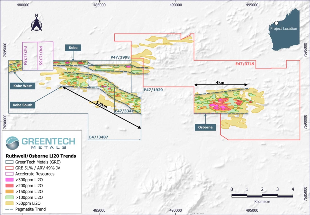
A significant lithium soil trend has been discovered at Kobe South which is southeast trending over a strike of 5.5km and varies in width from 300m up to 1km. Unlike Kobe despite the strong and persistent lithium soil anomalism, at surface pegmatite exposure has not been identified suggesting that the structure may be recessive or poorly exposed. Kobe South is considered to likely represent a western extension to the Osborne cluster which is exposed at surface and located 3.4km to the east within the Osborne JV tenement E47/3719 (GRE-51%:ARV-49%).
Forward exploration programs will focus on defining the full extent of the Kobe mineralised pegmatite trend and identifying zones where the pegmatite has potentially thickened the consistency of the lithium minerology and grade. At Kobe South the focus will be on identifying and testing pegmatite which is believed to be the cause of this extensive lithium soil anomalism. A program of shallow RC drilling will be implemented to investigate both Kobe and Kobe South.
Geology
The Ruth Well nickel-copper deposits were discovered by Whim Creek Consolidated NL (Whim Creek) in 1971. Mineralisation comprises violaritised pentlandite, pyrrhotite, gersdorffite, niccolite, chalcopyrite, and magnetite within serpentinised extrusive peridotite of the Ruth Well Formation. This association suggests that the deposits are of a similar type to the extrusive Kambalda nickel deposits of the eastern Yilgarn Craton. The mineralisation however probably lies within a tectonic slice of the Andover Intrusion that has been faulted into the Ruth Well Formation of the Roebourne Group on the northern side of the major, approximately 300 kilometres long Sholl Shear Zone.
Previous Exploration
The most significant work to have been completed in the Ruth Well project area was by Westfield NL between 1969 and 1975, Titan Resources NL (Titan) between 1989 and 2002 and Fox Resources NL (Fox) between 2004 and 2015. These companies carried out a series of open hole percussion, RAB, RC and diamond drilling programs.
Titan completed a TEMPEST AEM survey in 2000 and Fox completed an airborne VTEM HEM survey in 2006. These surveys provided coverage over the broader Ruth Well project area, however given the high base frequency utilised (25 Hz) these surveys were unable to resolve highly conductive EM targets amongst broader, more extensive stratigraphic/formational conductive units. Fox completed a ground-based SQUID EM survey in 2007.
Previous drilling in and around the Ruth Well project area comprised 426 drill holes including open hole percussion, RAB, RC and diamond drilling for a total of approximately 18,827 metres. Artemis Resources (ASX:ARV) drilled another 37 RC drill holes and one diamond drill hole for an additional 2,923 metres in 2018.
Figure 1: Ruth Well project location
Figure 2: Lithium soil trends at Kobe and Osborne
Figure 3: Soil sampling anomalies and outcrop mapping to date in the Ruth Well project area
Figure 4: Local geology of the Ruth Well project area


